Dosiye:Hopetoun falls.jpg

Ingano yiri shusho:800 × 533 pixels. Indi ingano zagutse: 320 × 213 pixels | 640 × 427 pixels | 1.024 × 683 pixels | 1.280 × 853 pixels | 2.560 × 1.707 pixels | 3.072 × 2.048 pixels.
Dosiye nyirizina (3.072 × 2.048 pixels, file size: 2,82 MB, MIME type: image/jpeg)
Incamake
| Umwirondoro |
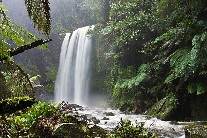
English: Hopetoun Falls, Beech Forest, near Otway National Park, Victoria, Australia. Taken with a Canon 10D and 17-40 f/4L lens.
Français : Cascade de Hopetoun, Forêt de Beech, près du Parc National d'Otway, état de Victoria, Australie. Image prise avec un Canon 10D et un objectif 17-40 f/4L.
العربية: شلالاتُ هوبتون العملاقة في غابة الزان بالقربِ من حديقة أوتواي الوطنية في مدينة فيكتوريا، أستراليا. |
| Itariki | |
| Inkomoko | Own work |
| Umwanditsi | Diliff |
| Permission (Reusing this file) |
Summary:In using this image or any subsequent derivatives of it, you are required to release the image under the same license. As such, any reproduction of this image, in any medium, must appear with a copy of, or full URL of the license.Attribution of this image to the author (DAVID ILIFF) is also required, preferably in a prominent location near the image.No other conditions may be added to, or removed from this license without the permission of the author and copyright holder.Suggested attribution: "Photo by DAVID ILIFF. License: CC BY-SA 3.0"Please review the full license requirements carefully before using this image. If you would like to clarify the terms of the license or negotiate less restrictive commercial licensing outside of the bounds of GFDL/CC-BY-SA, please contact me by email, or if you don't have a Wikipedia account you can either leave a message on my talk page with your contact details and your request, or you can contact me on Facebook. Please also send a 'friend request' to ensure that I am aware of your message. |
| Other versions |

| Camera location | | View this and other nearby images on: OpenStreetMap |
|---|
Assessment
|
}
Uruhushya
I, the copyright holder of this work, hereby publish it under the following licenses:
This file is licensed under the Creative Commons Attribution-Share Alike 3.0 Unported license.
Attribution: Photo by DAVID ILIFF
- Ufite umudendezo:
- gusangiza – to copy, distribute and transmit the work
- to remix – gutangira ibikorwa
- Under the following conditions:
- umurimo – You must give appropriate credit, provide a link to the license, and indicate if changes were made. You may do so in any reasonable manner, but not in any way that suggests the licensor endorses you or your use.
- imigabane isa – If you remix, transform, or build upon the material, you must distribute your contributions under the same or compatible license as the original.

|
Permission is granted to copy, distribute and/or modify this document under the terms of the GNU Free Documentation License, Version 1.2 or any later version published by the Free Software Foundation; with no Invariant Sections, no Front-Cover Texts, and no Back-Cover Texts. A copy of the license is included in the section entitled GNU Free Documentation License. |
You may select the license of your choice.
Amateka ya dosiye
Kanda kwitariki/n'isaha kugirango ufungure dosiye nkuko yagaragaye cyagihe.
| Itariki/Isaha | Ifoto ntoya | Ibipimo | Umukoresha | Comment | |
|---|---|---|---|---|---|
| muri iki gihe | 19:06, 13 Ukwakira 2009 | | 3.072 × 2.048 (2,82 MB) | Diliff | Reupload original file at 3072x2048 res |
| 02:27, 30 Ukwakira 2005 |  | 1.400 × 933 (667 KB) | Diliff | Hopetoun Falls, Beech Forest, near Otway National Park, Victoria. Taken on the 27th of July, 2005 with a Canon 10D and 17-40 f/4L lens. |
Ikoreshwa rya dosiye
Ibi bikurikira 9 imikoreshereze yarwo iyi dosiye:
- Ibidukikije kamere
- Ibidukikije n'iterambere mu bukungu
- Imiterere myiza y'ibidukikije
- Imiterere y’ibidukikije mu Rwanda
- Ishyirahamwe ryo kubungabunga ibidukikije mu Rwanda
- Iterambere ry'ibidukikije
- Ubumenyi ku bidukikije
- Ubuzima bwiza bwibidukikije ni Ubuzima bwiza bwa muntu.
- Ubuzima bwiza bw’ibidukikije
Ikoreshwa rya dosiye rusange
Izindi wiki zikurikira zikoresha iyi dosiye:
- Ikoreshwa kuri af.wikipedia.org
- Ikoreshwa kuri ang.wikipedia.org
- Ikoreshwa kuri an.wikipedia.org
- Ikoreshwa kuri ar.wikipedia.org
- Ikoreshwa kuri azb.wikipedia.org
- Ikoreshwa kuri az.wikipedia.org
- Ikoreshwa kuri ba.wikipedia.org
- Ikoreshwa kuri bcl.wikipedia.org
- Ikoreshwa kuri be-tarask.wikipedia.org
- Ikoreshwa kuri beta.wikiversity.org
- Ikoreshwa kuri be.wikipedia.org
- Ikoreshwa kuri bew.wikipedia.org
- Ikoreshwa kuri bg.wikipedia.org
- Ikoreshwa kuri bh.wikipedia.org
- Ikoreshwa kuri bn.wikipedia.org
- Ikoreshwa kuri bo.wikipedia.org
- Ikoreshwa kuri br.wikipedia.org
- Ikoreshwa kuri bs.wikipedia.org
- Ikoreshwa kuri btm.wikipedia.org
- Ikoreshwa kuri ca.wikipedia.org
- Ikoreshwa kuri ceb.wikipedia.org
- Ikoreshwa kuri ce.wikipedia.org
- Ikoreshwa kuri ckb.wikipedia.org
- Ikoreshwa kuri ckb.wiktionary.org
- Ikoreshwa kuri cs.wikipedia.org
View more global usage of this file.