Dosiye:Australian Census 2011 demographic map - Australia by SLA - BCP field 2817 Infants Primary Total Persons.svg

Size of this PNG preview of this SVG file: 762 × 600 pixels. Indi ingano zagutse: 305 × 240 pixels | 610 × 480 pixels | 976 × 768 pixels | 1.280 × 1.007 pixels | 2.560 × 2.015 pixels | 2.000 × 1.574 pixels.
Dosiye nyirizina (SVG file, nominally 2.000 × 1.574 pixels, file size: 9,53 MB)
Incamake
| Umwirondoro |
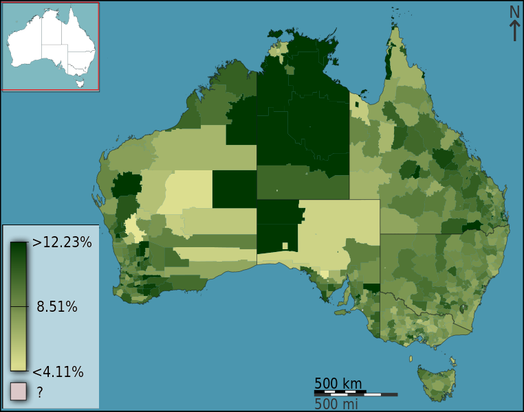
English: People attending an infants or primary school as a fraction of total persons, in Australia, Australia, according to the 2011 census results. The map is divided into geographical subdivisions by Statistical Local Area. Note the split scale above and below the median value. |
||
| Itariki | |||
| Inkomoko |
Own work
|
||
| Umwanditsi | Toby Hudson based on data from the Australian Bureau of Statistics |
Uruhushya
I, the copyright holder of this work, hereby publish it under the following license:
This file is licensed under the Creative Commons Attribution-Share Alike 3.0 Australia license.
Attribution: Toby Hudson based on data from the Australian Bureau of Statistics
- Ufite umudendezo:
- gusangiza – to copy, distribute and transmit the work
- to remix – gutangira ibikorwa
- Under the following conditions:
- umurimo – You must give appropriate credit, provide a link to the license, and indicate if changes were made. You may do so in any reasonable manner, but not in any way that suggests the licensor endorses you or your use.
- imigabane isa – If you remix, transform, or build upon the material, you must distribute your contributions under the same or compatible license as the original.

Amateka ya dosiye
Kanda kwitariki/n'isaha kugirango ufungure dosiye nkuko yagaragaye cyagihe.
| Itariki/Isaha | Ifoto ntoya | Ibipimo | Umukoresha | Comment | |
|---|---|---|---|---|---|
| muri iki gihe | 11:29, 3 Nyakanga 2013 | | 2.000 × 1.574 (9,53 MB) | File Upload Bot (99of9) | =={{int:filedesc}}== {{Information |Description={{en|{{ucfirst:{{Australian2011CensusMaps/bcpfieldcat/2817}}}} as a fraction of total persons, in Australia, Australia, according to the 2011 census results. The map is divided into geographical subdivisi... |
Ikoreshwa rya dosiye
Ibi bikurikira abakoresha urupapuro iyi dosiye:
Ikoreshwa rya dosiye rusange
Izindi wiki zikurikira zikoresha iyi dosiye:
- Ikoreshwa kuri en.wikipedia.org
- Ikoreshwa kuri ja.wikipedia.org
- Ikoreshwa kuri uk.wikipedia.org
- Ikoreshwa kuri zh.wikipedia.org