Dosiye:LocationStHelena.PNG
No higher resolution available.
LocationStHelena.PNG (465 × 303 pixels, file size: 12 KB, MIME type: image/png)
Incamake
| Umwirondoro |
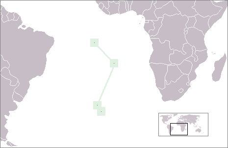
English: Location of the British overseas territory of St. Helena, Ascension und Tristan da Cunha in the Atlantic Ocean |
| Itariki | |
| Inkomoko | Own work |
| Umwanditsi | Telim tor |
Uruhushya
| I, the copyright holder of this work, release this work into the public domain. This applies worldwide. In some countries this may not be legally possible; if so: I grant anyone the right to use this work for any purpose, without any conditions, unless such conditions are required by law. |
Amateka ya dosiye
Kanda kwitariki/n'isaha kugirango ufungure dosiye nkuko yagaragaye cyagihe.
| Itariki/Isaha | Ifoto ntoya | Ibipimo | Umukoresha | Comment | |
|---|---|---|---|---|---|
| muri iki gihe | 09:03, 23 Nyakanga 2009 | | 465 × 303 (12 KB) | Telim tor | with frame |
| 08:53, 23 Nyakanga 2009 |  | 465 × 303 (9 KB) | Telim tor | == {{int:filedesc}} == {{Information |Description={{en|Location of the British overseas territory of Saint Helena in the Atlantic Ocean}} |Source={{own}} |Date=2009-07-23 |Author=Telim tor |Permission= |other_versions= }} == {{int:lic |
Ikoreshwa rya dosiye
Ibi bikurikira abakoresha urupapuro iyi dosiye:
Ikoreshwa rya dosiye rusange
Izindi wiki zikurikira zikoresha iyi dosiye:
- Ikoreshwa kuri am.wikipedia.org
- Ikoreshwa kuri ar.wikipedia.org
- Ikoreshwa kuri de.wikivoyage.org
- Ikoreshwa kuri en.wikipedia.org
- Ikoreshwa kuri ka.wikipedia.org
- Ikoreshwa kuri pl.wikipedia.org
- Ikoreshwa kuri sl.wikipedia.org